
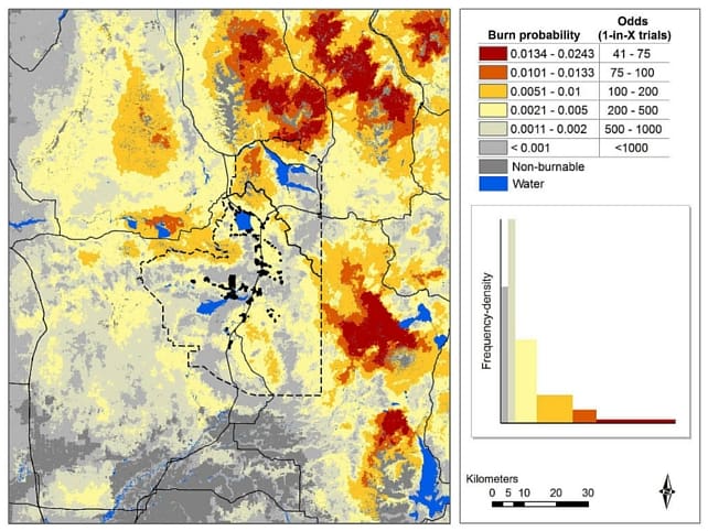
Photo Credit: Researchers developed this burn probability map for the Island Park Sustainable Fire Community project area (inside the dashed line). Photo by USDA Forest Service
Over the last three years, the Island Park Sustainable Fire Community (IPSFC) has been working with fire behavior researchers and modelers to better understand not only the threat of wildfire now, but the threat in the future to developed areas located in our focus area. We also asked the researchers to model effects of various fuels treatments on fire behavior, both adjacent to and further away from developments. No big surprise at the overall results: treatments close to structures are more effective in protecting those structures than treatments much further from structures.
Project Details
We worked with Don Helmbrecht, a fire management specialist associated with the Forest Service Enterprise TEAMS and Joe Scott and Julie Gilbertson-Day, researchers with Pyrologix LLC.
We had four questions:
- What types of fire will burn in this landscape and under what conditions?
- What areas are most at risk from fire?
- Where on the landscape may fires burn for ecological benefit but be unlikely to threaten developments in Island Park?
- What treatment strategies are effective at creating a future sustainable fire community?
Wildfire risk was based on an assessment of the likelihood of fire, the predicted intensity and the susceptibility of structures to fire. Data used to determine likelihood and intensity of fire were based on fuels, topography, historical weather and fire occurrence, and the probability of fire suppression. Susceptibility was based on an index assigned to each structure and property developed by collecting information based on RedZone software. This index included things like vehicle access, building materials and defensible space.
Researchers ran the FSim model based on four different scenarios:
- Current condition based on LANDFIRE 2010 data,
- Future fire behavior (2055) with no treatments or other disturbances,
- Future fire behavior if treatments were done near structures, and
- Future fire behavior if treatments were located 1 to 5 miles from structures.
Key Findings
Findings from the modeling effort showed:
- Worsening fire risk into the future as the vegetation matures,
- Treatments nearest communities provide the greatest reduction in risk to fire,
- Modeled treatments prove costly for minimal reduction in structure risk, and
- IPSFC and residents should focus on decreasing structure susceptibility onsite by:
- Asset hardening,
- Creating defensible space, and
- Completing fuel treatments to decrease potential on-site intensity.
IPSFC intends on using this information to:
- Prioritize areas that are currently at high risk for fire, and areas that will be at high risk for fire for fuels treatments specific to each property that would reduce the susceptibility of the property to fire;
- Prioritize areas adjacent to developments that are or will be at a high risk to fire for fuels reduction treatments;
- Inform residents, visitors and forest users about fire risks, where they are the highest and what could be done to mitigate them; and
- In areas where landowners or managers don’t minimize the risks, develop egress and ingress projects to increase firefighter and public safety.
IPSFC is interested in hearing whether other groups have had success using studies such as this one to raise public awareness. (Feel free to comment below.) Please contact me if you are interested in seeing the final report for this project.
Please note that comments are manually approved by a website administrator and may take some time to appear.