

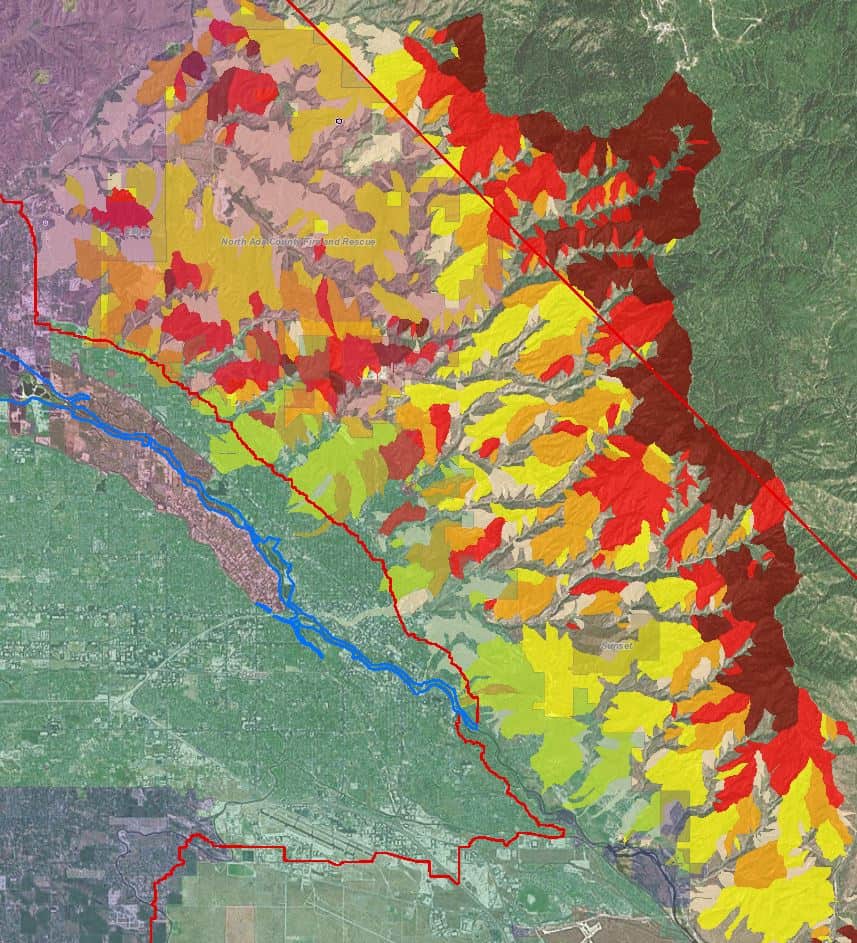
Photo Credit: Ada County Wildfire Riskmap – Clipped from Intterra SituationAnalyst (SA) by Jerry McAdams
The last year has been an exciting time to explore and develop new spatial tools in Ada County, Idaho. We have worked with a wide variety of collaborators, and discovered new programs and technologies that help us make informed decisions and better tell our story.
Over the last year, we have worked collaboratively with Ada County Emergency Management, Eagle Fire Department, Meridian Fire Department, Kuna Rural Fire District, Star Fire Protection District, Boise State University, Idaho BHS, Intterra Group, Quantum Spatial and others to create an Enhanced Wildfire Riskmap for Ada County utilizing new acquisitions of remote sensing data (LiDAR and RapidEye), along with a broad range of individual GIS risk layers. This project was finalized in June and includes several major hazard categories, including built-up hazard rating, highly valued resources, debris flow assessment, fire behavior, fuels classification, and more. The debris flow assessments were produced through the Boise State University Department of Geosciences by one of their graduate students, Katie Gibble, who is conducting some terrific research in this area; she also happens to be our summer Wildfire Mitigation Intern.
Ada County Wildfire Debris Flows – Clipped from Intterra SituationAnalyst (SA) by Jerry McAdams
The next iteration will start this month with a web-based Situation Analyst (SA) platform, to be utilized by emergency service agencies in Ada County for enhanced situational awareness. The new platform will help inform decision making in mitigation activities and tactical wildfire operations, providing greater safety for firefighters, law enforcement and the community as a whole. The platform is being funded by a grant from the Western States Fire Managers, it’s being built by Intterra Group, and it will be managed by the Idaho Department of Lands. It will include a mobile application for wildfire home safety assessments. The overall risk map and home assessment data will be made publically available on our website, www.adafireadapted.org, to be utilized as a tool by homeowners, businesses and government agencies as they work to build and promote a more fire-adapted Ada County. Other partners in the FAC Net are utilizing Intterra’s SA platform to provide enhanced situational awareness to their communities, as well.
Along these same lines, we are just getting our feet wet utilizing a feature of ArcGIS called Story Maps, which lets us integrate maps with images and text and helps us tell our story to a broader audience. Check out a very rough initial draft of a Story Map that we are currently working on, or visit Ashland’s Story Map. To see examples of what is possible with Story Map, check out other unrelated Story Maps. The project is really exciting and is a great example of the types of new spatial tools and technologies that can be used to promote wildfire adaptation. Utilizing current GIS data and creating interactive tools and information for our stakeholders is one of our primary focal points at this time, and we’re excited to have had so many collaborators and opportunities over the last year.
Please note that comments are manually approved by a website administrator and may take some time to appear.
Wow! What awesome tools! I hope to learn more about their design and functionality. They seem to have everything we wish we had down here.
Great look. Storytelling itself can be a significant influence on attitudes and bah ours. Combining with graphics and maps looks like a winner.