

Photo Credit: Spatial management processes, such as the development of Potential Operational Delineations, is creating pathways for more informed, collaborative and safety-focused wildfire management. Photo by USDA Forest Service
At the end of a windy summer day, an engine captain receives a smoke report from the dispatch center, readies his crew, and heads up the mountain in search of the fire. The crew rounds a bend and finds the flames. The fire is approximately 1-acre and located on a steep, rocky hillside. The area is covered in dead, standing trees that were killed during the last bark beetle outbreak. In our suppression-dominated past, the captain and his crew would have left their engine and trekked a thousand feet up the hillside, dragging heavy hand tools, chainsaws and supplies with them. Once there, they would begin cutting trees, digging line, spraying water, and trying to keep the fire as small as possible. Without having completed a detailed cost-benefit analysis or risk assessment, those firefighters would have a singular focus: putting the fire out as quickly as possible.
In scenes like that, or during wildfire response more generally, it is often difficult for firefighters to quickly and fully consider the risks that they expose themselves to, the potential ecological benefits that the fire could provide, or if the nearby values at risk actually necessitate fire suppression. When firefighters do stop to consider these factors, they may find that it makes sense to back off to a nearby road, for either ecological or safety reasons. Still, they often have little agency to change strategy, and even if they could, they are unsure if their decision would be supported and who would be blamed if things went awry.
In an effort to change this approach, scientists at the USDA Forest Service Rocky Mountain Research Station and the Colorado Forest Restoration Institute are promoting a new initiative that combines local knowledge from firefighters and resource specialists with advanced spatial analysis. The resulting output is a detailed risk assessment, capable of informing wildfire planning and response before the fire even starts. By mapping potential control lines that could be used to help contain wildfires (i.e., control features such as roads, trails, ridgelines, drainages, old burns, recent fuel treatments and pretty much anything that could keep a fire in check), land managers collaboratively develop Potential Operational Delineations (PODs).
PODs can range in size from several hundred to several thousand acres and are mapped irrespective of jurisdictional boundaries. Experienced firefighters already think about the landscape in this way, but in the past, this information remained in their heads and was unavailable to others who were less familiar with a given firescape.

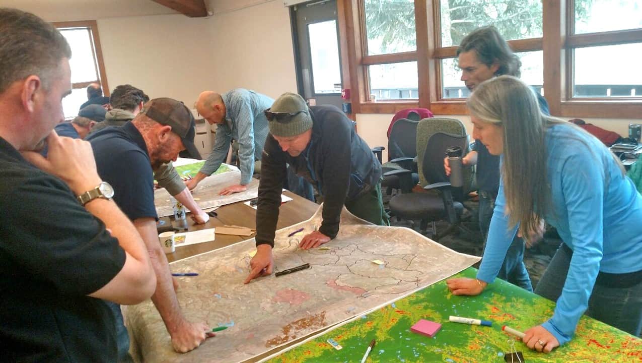
Hand-drawn Potential Operational Delineations (PODs) on a map of the northern Colorado Front Range. These PODs consider control features in relation to topography, timber, wildlife habitat and critical water infrastructure. Credit: Mike Caggiano, Colorado Forest Restoration Institute, Colorado State University
Improved Situational Awareness
In addition to mapping out control features, PODs can incorporate other information, such as values at risk, topography and vegetation. The process incorporates these data into models that then help stakeholders understand the difficulty of suppression, the likelihood of a given control line’s effectiveness, and the ecological effects fire could have under a range of conditions. Seeing all of that information on one map allows stakeholders to better understand potential risks and benefits and to develop fire management strategies. In short, it frontloads much of the planning associated with wildfire response, control features and wildfire behavior.
Heightened Communication, Stronger Relationships
Because these maps are developed collaboratively, they also help improve relationships and stakeholder buy-in. They improve communication among resource specialists, line officers and the public. Further, this effort serves to empower firefighters to make decisions that not only encourage safe and effective fire response but also improve forest health. Because the maps are developed collaboratively and utilize detailed risk assessments, local firefighters know they are making smart decisions and that their actions will be supported by the line officers, agency administrators and communities.
Firefighters, land managers and resource specialists use the POD process to develop spatial fire management strategies for a portion of the Colorado Front Range. This particular effort was supported by the Northern Colorado Fireshed Initiative, a local watershed collaborative that includes the USDA Forest Service, fire departments, conservation groups, businesses and community members. Credit: Mike Caggiano, Colorado Forest Restoration Institute, Colorado State University
An Example from Arizona
The Tonto National Forest recently conducted POD planning, and last year it successfully leveraged that effort to manage several wildfires, illustrating the utility and flexibility of this approach. In areas with high values at risk, such as communities living in the wildland-urban interface, fires were aggressively attacked and kept small using pre-identified control features, such as roads. Fires in PODs that were in poorly accessible wilderness were managed when conditions were favorable, and then controlled from POD boundaries when conditions changed. PODs aren’t one-size-fits-all prescriptions, and they don’t limit the decision-making process. However, through pre-planning before the fire, they provide a detailed analysis, clearly articulated objectives and an informed response strategy. Firefighters can now focus on incident strategies and tactics, while knowing that they have the support of managers and buy-in from local stakeholders.

A map of Tonto National Forest’s PODs, color-coded according to the ideal management strategy for each respective POD. Credit: Kit O’Connor, Rocky Mountain Research Station
Recently a manager explained the benefit of this effort from her perspective. She explained that conducting the analysis ahead of time improved situational awareness and communication flows, as well as provided consistent responses. After having gone through this mapping and analysis process with her staff and local cooperators, it took pressure off firefighters, incident commanders and agency staff. Her team can now view ignition locations in the context of PODs, allowing them to quickly identify and implement objectives as well as wildfire response and management strategies under a range of conditions. POD preplanning facilitates smart and transparent decision making, allows good fire to burn under the right conditions, and informs aggressive strategies when fires need to be suppressed.
In terms of the fire I described at the beginning of this post, after going through a spatial fire management planning effort, perhaps the fire could be managed differently. Out of consideration of crew safety, the incident commander might decide to back off to the road to the valley bottom which was already identified as the most effective nearby control line. The fire would then be allowed to burn, slowly backing down the hill, consuming dead beetle kill, and recycling nutrients back into the soil. Clearing the forest of dead trees would help create a healthy and more heterogeneous forest stand structure, one capable of improving the watershed while protecting communities from future, more catastrophic fires.
Author’s note: If have questions about the POD approach and/or are interested in receiving assistance in developing PODs for your local landscape, please contact me. You can also learn more about the science and application of PODs by viewing this webinar, or by reading this paper.
Please note that comments are manually approved by a website administrator and may take some time to appear.
Great tool and effort. seems like lots of buy in and learning would happen during the exchanges of creating this map and information. I am sending to my FMO on the Forest to potentially initiate this on our Forest
Nice post! Clearly lays out the need for this pre-planning to be a standard procedure done with multiple stakeholders.
Great, really great stuff.
Could we use this in Santa Fe on the Fireshed? Might be a neat way to discuss the different fire regimes/forest types and management areas…
So fantastic to see this all coming to fruition. Great post, Mike! You lay out the rationale and the approach, along with clear and compelling examples. Thanks!
Liz,
That’s great that you think this might benefit your Forest. I really think this is a flexible approach that can be implimented a number of different ways. I would be happy to discuss this further with you . Feel free to contact me directly .
Collin, I like that idea and PODs could be an organizing structure for the still in draft resilience strategy.
This is very similar to a method I started implementing in South Africa Last year and we are still busy rolling out. Where you call them PODS we call them sectors, However what we have done is to map each sector separately on an A3 size paper, this allows us to scan and email each map and store them electronically.
All landowners that we work with can at least print in either a3 or at least in A4 giving access to many people. Once the maps have been completed they are uploaded onto our Fire Websites where limited access is given to a select few.
This way Insurance companies can gain access to the maps if they want to insure a client in a sector. This allows Insurers to get a look at the bigger picture surrounding a farm/ranch, this is done in an attempt to make use of the leverage that insurance companies hold. (Some insurers have indicated that they will either reduce an individuals premiums or increase the cover they offer)
It amazes me that none of us in the Fire World never thought of this 20 years ago.
Our next step is to match our Identified Hazards and risks against Burn scars, this will inform us how accurate we were in identifying our hazards. (naturally one cannot eliminate all hazards but its an attempt)
Good write up, Mike! Applying the time and effort to pre-load these planning actions collaboratively makes so much sense. Do you know where the POD development stands for the forest currently?
Thanks for your interest Dan.
After the initial effort described in this post, we have continued to develop this spatial fire planning tool. This involved overlaying pod boundaries with a variety of spatial data-sets to summarize ecological resources, fire hazard levels under different weather conditions, and high value risks and assets for each pod. We are now developing desired conditions at both the pod and landscape scales, and are using fire models to identify under what weather conditions the Forest can both maintain control of the fire and achieve land management objectives.
We are also starting to see a change in how some fires are managed here. While thankfully its been a slow fire season in Northern Colorado, the Sugarloaf fire is being managed differently than many in the past. It has several parallels with the hypothetical fire described in this post. The fire started in steep and rugged terrain in a remote location that experienced a pine beetle epidemic. The Forest is actively managing the fire and identifying potential control locations, but it is not fighting the fire directly because of safety concerns. It is too early to tell if this represents a cultural shift here, but the combination of new leadership on the Forest, spatial fire planning, and the recognition that either we manage fires or they will manage us is a refreshing change.