

Editor’s note: This blog is another installment in our Project Firehawk series, the series is named in reference to a cohort of Australian birds who carry fire in their beaks to spark change. Its essays explore the core underpinnings of our work, and in some cases, challenge the status quo. We have asked the series’ authors to be bold as they tackle hard questions to reveal needed shifts in our relationship with fire. We have asked them to be unafraid as they point out what is (and isn’t) working in our current system. These thought pieces may challenge you, create controversy, or even cause you to stand up and cheer. Regardless of your reaction, we hope this series causes you to pause and maybe even initiate a larger conversation about what it really means to live better with fire. All images, maps, and figures are credited to the author unless otherwise noted.
The Calamity Tour
I used to think I knew what was going on in the woods. I’ve been navigating the worlds of forestry and wildfire since the late ‘90s, when GIS mapping was just beginning to be used operationally on large fires. I’ve spent my career surveying wildfire hazards with drones, light planes, helicopters, and dirt bikes, analyzing whatever wildfire-related GIS data or imagery I could get my hands on. My coworkers and I have spent the last two decades mapping over 250 of California’s largest wildfires – in 2021, we printed enough fire maps to cover two acres. But when it comes to describing the scale of our wildfire crisis, I feel pretty lost.
This spring, Lenya Quinn-Davidson, with University of California’s Agriculture and Natural Resources program, asked me to help lead a field tour in Butte County for the national Fire Networks team. The Fire Networks are a partnership that works through three interconnected peer learning networks – the Fire Learning Network, Fire Adapted Communities Learning Network and the Indigenous Peoples Burning Network – and supports the Prescribed Fire Training Exchanges (TREX/WTREX). This partnership is supported by a cooperative agreement between The Nature Conservancy and federal land management agencies to support people building better relationships with fire in places across the United States.
The previous summer, Lenya and I had been out to look at the reconstruction of Paradise following the 2018 Camp Fire and she wondered if I’d be interested in taking the group on a similar tour. I don’t really like spending time in the new version of Paradise. Old Paradise had shade and a funky charm. Now it is hot, dusty, windy, covered with Scotch broom and new modular homes; being up there triggers mourning for both what we’ve lost, and what we’re sure to lose again. I’d rather go just about anywhere else. We agreed, though, on the need to subject the group to some of the big carnage around here, not little feel-good local projects.
Over the years, I have noticed that every time a wildfire lays down when it runs into a fuel reduction project, we trot out a congressional delegation to tour the site, write papers about it, or turn the success story into catchy graphics for social media. We rarely tour the places where fuel breaks failed, or talk openly about the limits we face in dealing with megafires. This tour would be for people who spend a lot of time thinking about how humans can coexist with fire. After what we’ve been through in Butte County, I’m convinced there are some places we shouldn’t waste our efforts. I thought dropping the group into the middle of the enormous calamity that is our new wildfire reality might help drive this discussion, and maybe I wanted to share my sense of disorientation and despair, too.
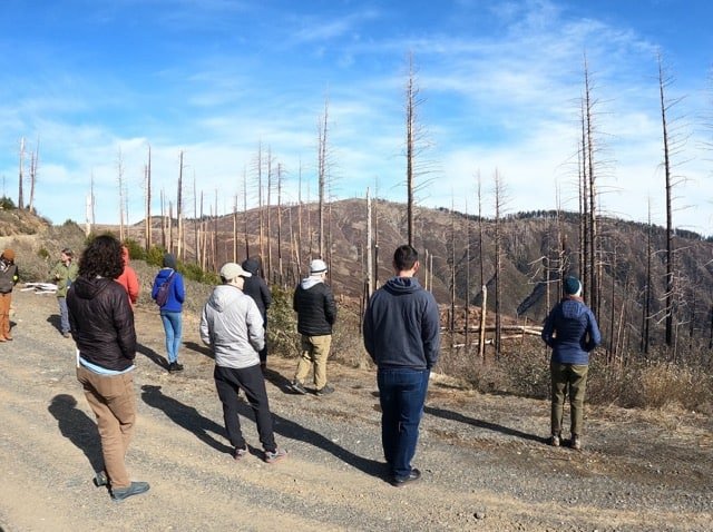
The Fire Networks team field trip in the Camp Fire footprint near Concow – 2023.
Trauma, Language, and Storytelling
We’ve been through a lot, here in Butte County. In 2017, historic floods threatened to breach the enormous Oroville Dam, and over 100,000 people were evacuated. Just up the hill from where I live, in Chico, the 2018 Camp Fire killed 85 people and made over 30,000 people homeless. Thirty of my coworkers lost their homes. For several years, friends and families hosted refugees in trailers and RVs in their driveways all over Chico. Nearly five years later, many have rebuilt, but people are still living in trailers on their properties; others live in tent camps on the edge of town. In the aftermath of the fire, heavy rainstorms pounded the burn, and the toxic stormwater from the 15,000-acre urban area of Paradise poured into our favorite swimming creeks. To our west, the 2020 August Complex burned a million acres across most of the Mendocino National Forest, choking our pandemic scene with months of smoke. To our east, the 2020 Bear Fire burned 400 square miles, leveled another 1,500 structures in the community of Berry Creek, and killed 16 people. To our north, the 2021 Dixie Fire incinerated the town of Greenville, and blackened a million acres of the lands I know best.
And that’s just the past six years. Before that, fires in 2008 threatened Paradise and wiped most of the community of Concow off the map. Many of the people who rebuilt lost their homes again to the Camp Fire (Concow also had a major fire in 2000).
When Lenya called, I had just visited Big Bald Rock, inside the Bear Fire scar. It was my first time up there since the area had burned, and I was struck with three superlatives: the huge areas of high-severity burn, the incredible density of the pre-fire forest, and the insane rates of regrowth in the oaks and brush.
I’ve always tried hard to avoid using loaded terms like “devastated,” “catastrophic,” or “scarred” to describe burned areas, but recently, I find myself using these words, usually prefaced with an F-bomb. Our landscapes and people are scarred and devastated. The outcomes of our recent fires are catastrophic. How else do we describe over two thousand square miles of black-stick forest, endless clearcuts of salvage-logged private land, and neighborhoods devoid of trees, peppered with blue-tarped trailers? It does look like a war zone. I know everything won’t be black forever, but our current situation is difficult to describe in neutral terms.
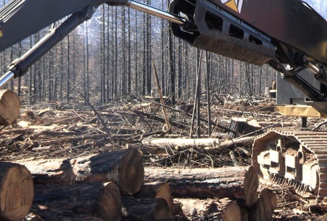
Salvage logging in the Dixie Fire.
We tell stories to try to make meaning out of the situation. Toward that end, I’ve created hundreds of maps explaining the cold, simple facts of the Bear, Camp, and Dixie Fires. In a single day, the Bear Fire marched 35 miles from red fir forests in the high-country to gray pine and live oak foothill scrub at Lake Oroville. The Camp Fire ran 18 miles in 12 hours, destroying almost 20,000 structures. The Dixie Fire’s biggest run consumed over 100,000 acres in two days. I enjoy teaching and talking about land, but lately, I feel maps fall short in truly communicating the staggering scale of change in our forests.

Twenty years of fire in Butte, Tehama, Plumas and Lassen Counties – Source: CalTopo.com

The 2020 Bear Fire in shades of yellow and brown. This fire burned about 400 square miles, and the diagonal of this map is over 50 miles wide. Lake Oroville in lower left.

The Camp Fire, about 15 miles wide, here, about four hours after ignition. In a strictly technical sense, this map is a great teaching tool about the limitations of fuel breaks during extreme weather, showing the fire spreading miles ahead of itself via long-range spotting. On a more human level, it utterly fails to capture the true horror of the scene. Yellow dots in the center show burning buildings. All of the major roads out of town are blocked by fires, and thousands of people are trapped inside this scene. Dozens have already perished. A regional maternity ward is on fire. Women are going into labor inside of burning ambulances, firefighters are trying to save the hospital, parents at work in the Valley can’t make it up the hill to pick up their kids from school or save their pets.

So many stories in one map. Looking over Chester, California. Red = high-severity burn. This map looks out over 70 miles of contiguous fire, a burned town, and a part of the Dixie Fire that in two days burned over 35% of the 100,000-acre+ landbase of a timber company that has been heralded as a leader in sustainable forestry. At one point in the summer of 2021, almost every citizen in Plumas County was evacuated or under an advisory evacuation.
Pace and Scale
The California Wildfire and Forest Resilience Task Force has a stated goal of “treating” a million acres of wildfire fuels a year by 2025. But what is our end game? Are we hoping to make every at-risk community fire safe? Do we think we can manage enough forest land to keep the next Dixie, Creek, Rim, Caldor, Camp, Carr, Ferguson, or Bear Fire from happening? Right now, there is a lot of interest in expanding the scope of prescribed fire, but the vast majority of acres being funded are thinning and mastication projects. There is no business case that suggests we can process and dispose of woody biomass for a million acres a year (the entire California timber industry has logged about 100,000 acres of private land per year over the past 20 years), and momentum toward building new utility-scale biomass cogeneration plants is slow.
Large-scale fuels treatments can have forest health and public safety benefits, and are critically-important to accomplish adjacent our forested communities, but California’s geography limits the amount of acreage we can mechanically thin, and on steeper, inaccessible slopes, prescribed and managed fire are our only real tool for managing fuels at the landscape scale. Despite a lot of talk about it, the US Forest Service is showing very little interest in using fire at the sort of scale needed to really make a difference, and California’s industrial timberland owners barely burn anything; most of them don’t even burn piles anymore. If we have more extended droughts, forest thinning projects alone aren’t going to stop megafires. We can’t mechanically thin the steep ground where fires like the Mosquito, Dixie, Carr, or Creek Fires grow large.
The assumption that large-scale fuels treatments can affect the outcome of megafires is rooted in all the success stories we’ve spread after forest thinning projects helped us control a wildfire, but timberlands comprise only a fraction of the wildlands where money is being spent on fuel breaks. In places with fast-growing brush, there’s very little lasting benefit to investments in large-scale backcountry fuels reduction. Take the example of the 2002 LNU Complex Fires.
Between 2015 and 2019, wildfires reduced fuel loading across about a half-million acres of the 1.5 million acre area in the map below. Yet when the 600 square-mile 2020 LNU Complex (black crosshatch) burned (destroying close to 1,500 structures, and killing six people), it ran across over 200 square miles of land which had burned within the previous eight years. One-hundred of these had burned just two years before. Just about anywhere we cut brush will need treatment again very soon, and forever is a long time. Are we going to keep asking taxpayers who live free of wildfire risks in Stockton, Long Beach, or Palm Desert to pay for this work in perpetuity?

Recent Fire History – Lake, Napa, Sonoma Counties.
890 square miles burned 2009-2019 shown in blue.
600 square miles burned in 2020 LNU Complex Wildfires (black cross hatch).
200 square miles reburned in 2020 (dark blue).
And in the timberlands, our recent experience with fires like Caldor and Dixie showed how ineffective even very extensive forest thinning projects can be at affecting changes in fire behavior under extreme wildfire conditions.

White areas show private industrial forests thinned to less than 50% canopy cover before the Dixie Fire (source). Red areas burned with high severity. Achieving and maintaining wildfire resilience requires constant intervention. Without a long-term commitment to follow-up, thinning forests is no guarantee of future survival.

Red areas show previous thinning projects on Forest Service lands within Caldor Fire. When fires are being spread by long-range spotting, small, isolated thinning projects don’t even slow the fire down. We need to cultivate realistic expectations about the conditions under which fuel breaks or extensive thinning will be effective.

Landscape-scale fire planning – Drawing Potential Operational Delineations (PODS) for the Lassen National Forest.
The Planning Trap
I’ve found a career niche working on “landscape-scale wildfire hazard assessment” projects. We use satellite imagery, fire history maps, parcel boundaries, roads, terrain, weather data and other map layers, along with our experience working on large fires to identify priority locations for large-scale fuels reduction projects.
So many things about planning work feel good! Modeling fire behavior and building GIS databases is not much fun, but drawing shapes on a map is cathartic – it feels impactful – and the solutions seem very clear. We’ll put in a ridgetop fuelbreak here, do a prescribed burn there, throw in some mastication and pile burning around the “assets,” and everything will be good to go! And there is the fieldwork component: we get to learn new landscapes, drive or ride bikes around in the woods, hike, look at past fires or logging projects, and share stories about land with other passionate people. For the most part, very few of the large-scale projects I’ve designed in my career have actually been implemented.

Fieldwork on the Lassen National Forest, 2020.
In 2019 and 2020, the company I work for, Deer Creek Resources, had funding from the U.S. Bureau of Reclamation and Sierra Institute to develop a conceptual plan for where to best thin and burn across the 850,000-acre South Lassen Watersheds Region. Since there was a pandemic going on, I was able to take my 8 and 10-year-old sons with me for the survey portions of the project. We escaped the choking wildfire smoke in the Valley and hiked into roadless old growth stands near my hometown of Westwood, shot big sugar pine cones out of tall trees with a .22, hung out in hammocks and camped near creeks; we got to explore places I’ve always wanted to see.
But within months of finishing our plan, about half a million acres of our project area got roasted by the Dixie Fire. Our fire effects models greatly underestimated the observed fire behavior. Many of the coolest old growth areas we had visited were destroyed, and areas we’d thought were in pretty good shape (thinned, actively managed) also got nuked. The Dixie Fire was devastating in so many ways, but the hardest part to swallow was the realization that even when we think we have technical solutions that might save our forests, the scope of our forest health problem is far beyond our ability to manage it. What made us think we could?

South Lassen Watersheds project analysis area in pink, Dixie Fire severity in red.
We talk a lot about the US Forest Service’s dwindling capacity, but the problem is more fundamental than any of that. Fire is the only tool that is really up to the job of managing fuels at the landscape scale, and the Forest Service is first and foremost a fire suppression outfit. As far as their land management capacity goes, they ramped up for about 45 years after World War II, to carve about 400,000 miles of roads into the backcountry and drag the largest trees off our Western landscapes. They followed this up with a flurry of tree planting, but not much tending. Then they got in trouble for all the bad things they had done, and we sent them to planning jail for the past 30 years.
For my entire career, the Lassen and Plumas National Forests have been involved in one landscape-scale planning effort after another. Literally millions of labor hours have been spent (skillfully) designing incredibly detailed projects to increase wildfire resilience, yet in the past 15 years, the landscape has lost more than half of its trees. The Dixie Fire burned through proposed, uncompleted projects which were funded out of settlements from fires that occurred as far back as 2000 and 2007!
The West is littered with relics of booms and busts. Forest Service offices are the latest ghost towns. A huge number of the trees they planted have turned to ash and smoke, and their amazing forest road network has been blown to pieces by storms and neglect. We’ve equated the ability to remove all the big trees with the capacity to manage ecosystems, but nobody really even knows how to do this. Wildfires are eating foresters’ lunch, regardless of their employer.

Plumas National Forest – Forest Cover 2017

Plumas National Forest – Forest Cover 2022

After the Camp Fire, Concow Road.
Learning the Limits
Maps and data visualizations can help us make sense of numbers and trends, but even the best ones require field-validation. Without proper context, our ability to conceptualize problems and plan appropriate solutions can become completely disconnected from reality. This becomes crushingly clear when you stand in Berry Creek or Concow, realizing everything you can see in all directions has been burned, and that there’s clearly no technical solution, either to preventing the next fire or “fixing” the damage from this one. That’s what the field trip was really about – ground truth.
People are small, forests are vast, mountains are rugged, logging is brutal, and economics are real. We can absolutely accomplish projects that will make our communities safer and forests more wildfire resilient, especially if we scale up our use of fire, but the megafire train left the station as soon as we started cutting down all the big trees and suppressing every fire. We are 100 years into this passage, and we’ll lose millions more acres of forest before the reset is complete.
In retrospect, we were negligent to take the Fire Networks team into the ruins of the Plumas National Forest without providing some structure to help people process it all – If you were on the tour, I’m sorry we didn’t prepare a better container for your encounter with our ravaged forests. Big burns are traumatic, the darkness is real. Have you had similar experiences visiting massive burn scars? How did they change how you think about the work we do? If we face the limits in our ability to truly work at scale, where do you think our work can be most impactful?

Members of the Fire Networks walk together on a tour of the burned area.
****
Thank you. Very well done. My intuition is that we simply don’t have in place any institutions that are prepared to engage with a challenge of this scale. I hope you’ll write next about what such institutions might look like.
Wow, thanks for sharing your thoughts and feeling and vast experience!
Zeke, this is all brutally honest and provides key perspective. Scale matters, especially when we have very large landscapes and increasingly larger, more intense wildfires. I agree prescribed fire is an essential means to changing the tragic trajectory. landscape prescribed fire can happen, it’s just going to require realistic investments such as dedicated incident management teams with all of the associated resources (i.e. helicopter support, crews, engines). And as others noted, concerted, social science based outreach to develop societal support. I still think there is a place for thinning and biomass but like you point out, right now it’s near impossible to even pay to get rid of it. You make a great point, it’s easier to thin than prescribe burn, so that’s what Happens. But it doesn’t make it better. More people should go on your tours and hear your stories. We don’t have time to discuss or develop new technology or tools. We all need to do as much as we can as fast as we can.
More controlled burning is a tough sell. I think one component should be, rather than trying to reintroduce fire to human communities, to instead focus on introducing the people to the fire. Like inviting the public to burning (yes, at night!). If the administrators get freaked out about red cards, it isn’t very hard to extrapolate how ordinary citizens are gonna feel about ANY fire. But how else will we ever approach the necessary political will to burn like we need to?
Yes, the FS can find a thousand reasons NOT to do something, but only one or two pathways to make it happen. We desperately need the public more on our side. The best place to learn fire ecology and fire natural history is on a real fire. Fire deserves better than a boogieman role here. The FS should grow a pair and take a lead role in this necessary outreach.
(For giggles, try estimating the cords of firewood an adequate thinning effort would produce. I’d bet on about 10 cords per year, forever, for every man, woman, and child. No doubt, it’s gonna take broadcast burning.)
Thank you for doing your tours … more or less in ash. I say, the hotter the ash, the better — wear boots and avoid deep white ash. Careful tours during prescribed burning (even just piles) is better yet. Walk up to the fire (preferably less than 4ft flame length at first) and introduce yourself.
Yes, it generally takes at least two wildfires to reset the natural burn cycle from our current suppression-impacted, over-stocked forests — the problem is maybe twice as big as it might seem. We totally gotta up our game, getting fire back into our normally fire-maintained landscapes. We gotta learn to live with fire. Frequent fire.
Fires with a more complex mosaic of severity, such as the August Complex in which some areas did not burn at all, seem to indicate that some regions will reset faster from 100 years of suppression than others. As you report, some areas burn at high severity every time. The horrible data that we are collecting ought to yield a pretty good map of how and when to burn, or allow fire, and where not to attempt a settlement.
I was about to say this is bleak Zeke. It must weigh on you. I don’t know how helpful this will sound, but you are making a difference. Your expertise, experience and clear writing are educating a lot of us – even those with forestry in our background – on the nature of fire in California.
I think some form of national service would be beneficial. For a number of reasons. Most people these days have absolutely zero rural background, getting young people working out in the woods couldn’t hurt, for skill building and for exposure to something more real than little screens. But I agree. The scale. It’s mind boggling. We are just not going to win this one, not in our lifetimes. At least not all the wildfire is stand replacing catastrophic, some of the forested areas burned are ok. I think we need to map those lesser affected areas, plan to put them in some kind of return interval for Rx burns. And quit with the new plantations already. We do not maintain them.
Thin and tend the existing plantations that haven’t burned already. Encourage fire resistant vegetation, like aspen stands. Might not do any good, given the rapidly evolving conditions. I wonder about aspen regen after the Dixie Fire. California is an island of cool for the last several months, the rest of the planet is roasting. But aspen stands are sort of super producers for wildlife, insects, soil building, plant diversity.
Zeke, this is awesome! Elegantly written, my exact thoughts, observations and conclusions .
I am looking forward to talking (solutions) with you, about how to frequently prescribe fire in the fire prone Wildland Urban Interface and throughout our fire adapted / dependent landscapes.
We can not permanently exclude fire, eventually it’s going to burn.
Either we frequently prescribe fire or experience cataclysmic “hell fire”.
Zeke, thank you. One of the things I really like about this piece is that you make being overwhelmed beautifully clear in so many different facets of experience. I find it very relatable.
In considering these increasingly familiar failures at landscape scale, I think about those instances of creativity at the human scale, like PBAs. We need more radical creativity at the human scale, not limited to known or sanctioned models. Perhaps we need a fuller sense of our human scale capacities. Respect to the previous commenter, but while formal, landscape scale institutions can help/hinder, I don’t think that they can be a leading edge of the changes that need to happen/are happening, in part because their reward structure just doesn’t match the needs that your piece illuminates.
I really appreciate this series, FACNet!
Thank you for all you do, Zeke. For someone working in and around this crisis, and surely for anyone impacted by it, this is obviously a tough read – you can feel the exhaustion and grief for what has been lost and what’s to come in your words. It’s even heavier because we know you understand this problem as well as nearly anyone. I’m grateful for your willingness to call it as you see it publicly, no sugarcoating, no matter how difficult it is to write and read.
What I would love to read next is a followup written by Zeke Lunder, King of California operating with an unlimited treasury and a 100 year guarantee that every order will be implemented. What would you do? What kinds of policy, prioritization, actions, etc would you bring to bear and why? If we aren’t going to give up, what’s the outline of the plan in your mind?
So many truths and pertinent questions here, especially the importance of ground truthing. Models, maps and tech can only show part of the picture. Thanks for a well written essay.
Your lines “The West is littered with relics of booms and busts. Forest Service offices are the latest ghost towns” brought a wry smile to my face as I took a break after a long planning meeting at Lassen National Forest offices, empty echoing places where “partners” (like me) and contractors (like you) are increasingly relied on to do the work federal employees once did, even as an incredibly dedicated and skilled skeleton FS workforce hangs on and tries to care for millions of acres of land. Yet the Forest Service is still incredibly effective at at least one thing: putting out small backcountry fires that aren’t doing anyone any harm. The day this piece was published, the Lassen put out 4 lightning-caused fires at under an acre, all burning under conditions that would be within prescription for many a prescribed fire (something I am sure was not lost on many of the firefighters asked to stomp out the smoldering duff). When it comes to suppression, nothing fails like success.
Thank you for your service, friend. I’m gonna echo Rukavina’s comment and observe that the psychic toll this work takes on you must be significant. It’s hard work to be a harbinger–you’re flying point for the whole V.
Also, yeah. Policies, actions, prioritization?
And, I’m down for a ridealong for any place that is too bleak to go alone. I know I’m not the only one.
Thank you for your honesty and for sharing this essay Zeke. If we can’t speak about about the hard reality of what our present world really looks like then we are never going to get to a place where we can live with fire, and lots of it, which we really need to be able to do, as fire isn’t going away as much as some might wish that it would.
I suppose then that helping people learn to live with our fire future (residents, land/fire managers and elected officials among other groups) would be my answer to your last question. The approach with each group involves different strategies, but the first unversal step is admitting that there is going to be a lot more fire on the landscape in our future than the past (century) .
Zeke, this blog post is cathartic, and thank you for saying so much that goes unsaid in this line of work. So much of our blue sky planning has been able to be realized now and for the next 5 years due to massive federal investment, but we need to temper our expectations of what even $1b+ can do in the face of our 100 year deficit and accelerating climate change. Perhaps it’s sheer optimism to say that we’ll keep going. But the work is personal for many of us and the passion comes from a strong sense of service to the land, its people, and our fellow practitioners. It’s devastating to see the fallout when even our best is not enough. None of us should have to go through it alone, and Zeke, I promise you are not alone. -Simone
Thanks, everyone, for your comments and support!
Great article Zeke-it is overwhelming for all of us who’ve watched the scale of fires, impacts, recovery grow over the last 20 years. We are stuck trying to make the various planning, funding, and treatment paradigms, all built for a very different world, apply today quickly at scale, all while doing it with extensive internal staffing, workforce capacity, and moral shortages-this is not exactly a recipe for success but at least for now, the hand we are stuck with. Do we fold, bluff, pass, or call-none of those options makes the hand any better….
A sincere thank you, Zeke. You’ve captured what I’ve found hard to articulate – and accept.
Zeke – thanks for sharing this. I first read it a couple of weeks ago and have been processing – you articulated several points that have been part of my experience here in the central rockies. Thank you.
One thing that stands out to me is the time scale. Our forest conditions and the resulting fire behavior didn’t occur quickly – the forest conditions we have are a result of a century or more of trying to exclude fire – we really cannot expect a quick fix. Our land use decisions over time in forested areas leaves us pretty poorly positioned to succeed in doing fuels work that will really be meaningful. I think we even need to reconsider what we identify as a forest. Most of us, probably, were imprinted at a young age on what a western conifer forest is. That impression may not be representative of what forest growns on that site over the long time scales of forest cycles and climate cycles. I’ve spent a career as a forester working to ensure that forest ecosystems are functioning based on that early impression of what a forest is. We are seeing the ecological responses – some dramatic and some less so.
Another thing that came to me – I recall a fire that burned through a forested community that had been pretty active in fuels mitigation work but it was really small lots on steep ground and heavy fuels (for here anyway). There was quite a bit of home loss and forest type change. In the review of the fire we were asked – “to what percentile fire behavior that the treatments we recommended were designed for”. I’m still at a loss to answer that question. We probably didn’t have an engineering-type design to begin with and I wasn’t aware of a percentile fire behavior in this treatment design. But as I thought about it – I don’t know how we’d do that – I don’t think we know what the top end of fire behavior is. You described the fire behavior and fire effects very well in your article. We don’t really know what fire behavior the forestry treatments we do will be exposed to. The engineering-type solutions don’t seem to fit very well.
I think our response is to keep working at it – the work does have value – to the ecosystem, to the people who care about it and to those who are doing implementation. Even these really large fires tend to have some differences in their fire effects – there will be some areas that fare better. It’s not helpful to identify a past or present villan in this. How I’ve reconciled it is to do my best with the natural resouce and the people – and that is enough. Some things we’ll get right and some things we will not. I’m learning to adjust my expectations of what a forestry treatment can be expected to do. Expecting a treatment to ‘stop the fire’ is not very realistic. My experience is that a treatment has to be over 10,000 (ish) acres, have removed a large percentage of the fuel and is less than a couple decades old to ‘stop the fire’. There can be some tactical opportunity with smaller treatments (ie burning out from a road). There can also be some less-negative, even positive, post fire outcomes. Very much worth doing but we have to expect that it will burn.
Thanks for writing the article.
I struggle w/ this very thing. Thank you for sharing your experiences.
Great work Zeke, thanks. Just getting the agencies and the politicians to stop cutting old growth was such a huge lift, it is hard to see how we can get these entities to put fire back in the forest at a meaningful scale. But it must be done. We took billions of board feet out of these forests, it is time to make some re-investment.
Taking the logic one step further. We need to work toward making communities fire permeable. We will not stop fires solely by manipulating wildlands. Our efforts need to go toward hardening our homes and communities so that serial structure fires do not take out thousands of homes. I would support remote sensing efforts that help determine which structures survive. There is some work on this but there has to be more info to share with homeowners and cities so they can make good decisions about home hardening and community development.
I was a prescribed fire manager, incident commander and wildland urban fire coordinator. I first used the concept “fire permeable communities” over 15 years ago in a paper I co-wrote on Alaska’s fire management system. It is a scary concept to think fire will go through your community, but it will. It’s not a matter of IF but WHEN. I designed and implemented fuelbreaks . They will not be adequate to address the phenomena of modern wildfire. Like the actor says in the TV ad about treating diabetes when he indicates flatlining may be a consequence—“Too much? That’s the point”. I am tired of having to soft pedal around with this issue–lives are at stake.
You said “Big burns are traumatic, the darkness is real. Have you had similar experiences visiting massive burn scars? How did they change how you think about the work we do? If we face the limits in our ability to truly work at scale, where do you think our work can be most impactful?”
Honestly I’ve gotten inured to the scars and fire aftermaths. I’ve lost track of how many big fires have burned through my various home lands.
I know now regrowth will be riotous. Maybe not the same vegetation, maybe the trees are gone forever. But the plants will bloom, and then the bugs, then the rodents and varmints come back. If it rains. Without rain it’s straight to badlands.
But I love the sudden unlimited access! Walk where no human has stepped for 50 or a hundred years! Find lost trails, new places, old homesteads. But only for a year or three, until things overgrow again.
I do not doubt the power of a hiker with loppers. I wish I had thinned areas in my first scar, it would have made a (small) forest’s worth of difference. When all the trees are a few feet tall, thinning 9 out of 10, or 99 out of 100, isn’t that hard.
Send out an army of kids, trained to thin, tell them they get to cut things down. Reward them. It won’t solve the problem, but around communities it can make a tangible difference through the years.
Regrowth is beautiful, in its own charred and misshapen way.
I love this comment, RJ. My kids and I have enjoyed the easy access after burns in Bidwell Park. It is a riot of growth. Burns can be enjoyable, but losing vast stretches of old forest is hard to stomach, too.
Zeke, its interesteing that your research mention going back 30 years. For example long term fire history showed that the paradise fire was going to happen after several previous fires over time marched that was and resulted in the loss of structurs from the fire before the major life-loss firestorm.
in 1977 I was a seasonal fire fighter in my fourth fire season with CalFIRE, then the Division of Forestry, working out of the Dobbins fire station in the Nevada-Yuba-Placer Ranger Unit. THis was during a drought cycle, one of many I’ve experienced growing up in Northern Claifornia since the late 1950’s. IN the 1977 season everything changed. OUr ability to control smaller fires and avoid large scale burns was totally overcome by the change in the fuel models and ROS. We were sent on a Strike Team to the Modoc Natl Forest to attack multiple lightining set fires. ONe of the largest ones we were committed to for 2 weeks, the so-called “Scarface Fire” approximately 89,000 acres burned and we feared the 28,000 acre Pondosa fire would become part of the complex. This fire almost killed us and burned up one of our fire engines on the first day. The smoke column rose to 30,000 feet.
Since that time I worked a career in the fire service e in the bay area and retired from Sacramento Metro Fire in 2006. We fought wildfires every year and did our best to protect life and property. Before I moved from the Grass VAlley area last year I served as an Evacuation Committee Chair andafter on the workgroup. Our Nevada County Coalition of 55 Firewise Communities could claim about 55, 000 people.
YOU present some interesting points about fire and what have we accomplished. MY take is on several points one of which is that over-zealous environmentalism is partly to blame. You cannot close 20 sawmills and expect to very well manage forest growth. Another issue is that yes, 100 years of fire suppression has been overly effective, however nature proliferates and it grows . THe third issue is that 100,000s of Californian’s now live in the wildland-urban interface whereas in previous decades they did not , thus increasing the life-safety peril. What do we do best? Remove the fuel, even as large of a task as it appears Go back to creating large fire breaks between more populated areas and the forest along with prescribed burning. Perhaps Install prearranged means of prventing ember streams from doing what they did in Santa Rosa and Paradise. YOu may find this link on the Caldor fire interesting: https://www.fs.usda.gov/features/caldor-fire-defending-lake-tahoe-basin . A previous fire took out many structures inSouth Lake Tahoe although they dont mention it in the articel. Keep doing what you are doing, perhaps some answer will come of it that works.